Mount Asama is one of Japan’s most active volcanoes, known for its frequent eruptions and dramatic volcanic activity. Located on the border of Gunma and Nagano Prefectures on Honshu Island, it has fascinated geologists and residents alike for centuries. Its most recent eruptions have captured public attention not only for their ash plumes and tremors, but also for the way they remind us of the power and unpredictability of nature. The last eruption of Mount Asama was an event that renewed interest in volcano monitoring and sparked conversations around disaster preparedness in Japan.
Geographical Background of Mount Asama
Location and Structure
Mount Asama rises to a height of 2,568 meters and is classified as a composite volcano. This type of volcano is built up by layers of hardened lava, tephra, and volcanic ash. Its symmetrical shape and prominent crater make it a prominent feature of the surrounding landscape. The volcano lies near the center of Honshu, the main island of Japan, and is part of the larger Japanese volcanic arc created by the subduction of the Pacific Plate beneath the Eurasian Plate.
Historical Eruptions
Mount Asama has a long history of eruptions, with records dating back to at least the 10th century. One of its most devastating events occurred in 1783, known as the Tenmei eruption, which killed over 1,000 people and triggered widespread famine due to crop failure. Since then, the volcano has erupted many times, with varying degrees of impact on nearby towns and communities. Its activity is constantly monitored due to the dense population in the region.
Details of the Most Recent Eruption
Date and Nature of the Eruption
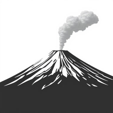
The last eruption of Mount Asama occurred on August 7, 2019. It was classified as a minor eruption but was still significant enough to warrant national attention. At approximately 1008 p.m. local time, the Japan Meteorological Agency (JMA) reported that an explosive event took place at the summit crater. The eruption sent a column of ash more than 1,800 meters into the air, which could be seen from towns kilometers away.
Warning Levels and Safety Measures
In response to the eruption, the JMA raised the volcanic alert level for Mount Asama from Level 1 (normal) to Level 3 (do not approach the volcano). This warning advised people to stay away from a 4-kilometer radius around the crater. Authorities quickly closed hiking trails and observation areas, and local residents were urged to remain alert to falling ash and the possibility of more eruptions.
Impact on Surrounding Areas
Air Quality and Ashfall
While the eruption did not result in major lava flows or pyroclastic flows, the ash that spread across parts of Nagano and Gunma prefectures did cause inconvenience. Light ashfall was reported in several towns, coating cars, windows, and crops. Residents were advised to wear masks and avoid unnecessary outdoor activities. Train lines and roadways operated normally, though they remained under close observation for potential ash-related disruptions.
No Casualties or Major Damage
Fortunately, there were no reported injuries or fatalities from the 2019 eruption. Emergency services remained on standby, and evacuation was not necessary. The volcano’s remote summit and well-maintained safety protocols contributed to minimizing any human risk. Nevertheless, the event served as a reminder of the potential hazards associated with active volcanoes in densely populated regions.
Monitoring and Scientific Analysis
Volcanic Activity Observation
Japan’s volcano monitoring system is among the most advanced in the world. The Japan Meteorological Agency and the Geological Survey of Japan maintain multiple observation points around Mount Asama, including seismographs, gas sensors, thermal cameras, and satellite imagery. Prior to the 2019 eruption, increased seismic activity and minor tremors had already indicated a possible eruption.
Gas Emissions and Seismic Signals
Scientists noted elevated levels of volcanic gases such as sulfur dioxide and carbon dioxide before and after the eruption. These gas emissions, combined with tremors known as volcanic quakes, typically provide clues about magma movement beneath the surface. Such data is critical in forecasting eruptions and issuing timely warnings to the public.
Preparedness and Public Response
Community Awareness
Japan’s long experience with natural disasters has led to a high level of public preparedness. Schools and businesses near Mount Asama regularly conduct earthquake and eruption drills. Evacuation routes are clearly marked, and local governments provide information booklets that explain what to do in case of volcanic activity.
Role of Technology
Smartphones and digital alert systems play a major role in keeping the public informed. When Mount Asama erupted in 2019, residents received real-time alerts through their mobile devices and local news stations. Apps developed by the Japanese government and private organizations track geological activity and send push notifications when conditions change.
Environmental and Long-Term Effects
Soil and Agriculture
While volcanic ash can damage crops and make air quality hazardous, over time it also enriches the soil with minerals. Regions around Mount Asama, especially in Nagano, are known for fertile farmland partly due to volcanic activity. Farmers often report improved soil conditions in the years following minor eruptions, once ash is absorbed and mixed into the ground.
Tourism and Economic Impact
Mount Asama is a popular destination for hikers, nature lovers, and photographers. After an eruption, tourism often declines temporarily due to safety concerns, but interest in the volcano tends to rebound quickly. Guided tours and educational exhibits about volcanoes also attract visitors eager to learn more about geological phenomena. The area’s economy, supported by both agriculture and tourism, has proven resilient despite occasional eruptions.
Comparisons to Past Activity
Frequency and Pattern
Compared to previous eruptions, the 2019 event was relatively minor. In the last few decades, Mount Asama has erupted roughly once every few years, usually with limited force. The 2004 eruption, for example, was more powerful, with lava ejected from the crater and more extensive ashfall. In contrast, the 2019 eruption caused minimal disruption and demonstrated the effectiveness of early warning systems.
Scientific Importance
Each eruption offers scientists valuable data that helps improve volcano prediction models. The 2019 eruption confirmed many of the indicators used to forecast volcanic activity, such as changes in seismic waves and gas output. Ongoing research aims to make eruption forecasts even more accurate, potentially saving lives and property in the future.
The last eruption of Mount Asama on August 7, 2019, was a mild but important reminder of the volcano’s active status. Though it caused limited damage, it prompted swift action from authorities and reinforced the importance of constant monitoring. As one of Japan’s most watched volcanoes, Mount Asama will continue to be studied for its geological significance and potential hazards. Residents and visitors alike respect the mountain not only for its natural beauty, but also for its powerful, unpredictable presence in the heart of Japan’s landscape.